
 MTB tour Montgenèvre - Chenaillet - Collet Vert - Montgenèvre (21 July 2021)
 |
Prarial pass, on the watershed divide between Doire and Durance 21-07-2021 10:25 6.7258°E, 44.9208°N, 2013m |
 |
Le Brousset, view to the south-west with the summit of Château Jouan (a.k.a. Janus) 21-07-2021 10:47 6.7292°E, 44.9192°N, 2110m |
 |
Towards Mont Chenaillet 21-07-2021 11:24 6.7367°E, 44.9128°N, 2260m |
 |
Between Grand Charvia and Chenaillet summits, from here is Chenaillet pass hidden 21-07-2021 12:22 6.7422°E, 44.9053°N, 2470m |
 |
View to the north-west from Chenaillet pass 21-07-2021 13:00 6.7478°E, 44.9039°N, 2519m |
 |
The Queyras alps as seen from the Chenaillet pass, with Lasseron mountain in front and Pic de Rochebrune in the background 21-07-2021 13:00 6.7478°E, 44.9039°N, 2519m |
 |
From Collet Vert, the valley of the Petite Doire stream (which becomes Dora Riparia further down) 21-07-2021 13:20 6.7508°E, 44.9092°N, 2521m |
 |
Val Gimont as seen from Collet Vert 21-07-2021 13:21 6.7508°E, 44.9092°N, 2521m |
 |
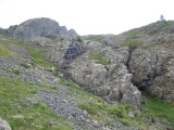
Kissenlava am Collet Vert, entstanden vor 170 Ma bei 2000 m unter dem Meer 21-07-2021 14:27 6.7508°E, 44.9092°N, 2521m |
 |
The sources of the Petite Doire stream 21-07-2021 15:06 6.7469°E, 44.9128°N, 2330m |
 |
Towards Montgenèvre and the Grand Chalvet mountain from the Petite Doire valley 21-07-2021 15:14 6.7458°E, 44.9136°N, 2290m |
 |
From the Petite Doire valley towards the Collet Guignard pass 21-07-2021 15:22 6.7450°E, 44.9147°N, 2260m |
 |
Col du Prarial as seen from the east 21-07-2021 15:50 6.7417°E, 44.9186°N, 2140m |
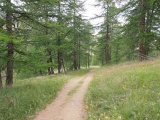 |
In the Petite Doire valley 21-07-2021 16:22 6.7342°E, 44.9231°N, 1940m |
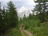 |
Angelika and Mont Chaberton 21-07-2021 16:27 6.7347°E, 44.9264°N, 1900m |
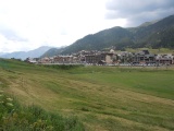 |
Montgenèvre 21-07-2021 16:39 6.7283°E, 44.9311°N, 1860m |