
 MTB tour Les Paccots - Tremetta - Saletta - Les Paccots (29 July 2018)
 |
22 km |
| 820 m ^ | |
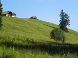 |
Gros Chalet in the Rathevi valley 29-07-2018 10:05 6.9697°E, 46.5306°N, 1140m |
 |
Rathevel pass, southbound 29-07-2018 10:26 6.9817°E, 46.5469°N, 1223m |
 |
View towards the northeast from the Villard pass 29-07-2018 11:11 6.9914°E, 46.5411°N, 1459m |
 |
The Villard Pass on its Les Paccots side 29-07-2018 11:11 6.9914°E, 46.5411°N, 1459m |
 |
The road going up to Trémetta, and the summit of Teysachaux 29-07-2018 11:29 6.9986°E, 46.5414°N, 1540m |
 |
Up towards Trémetta, view towards the north-west 29-07-2018 11:37 6.9986°E, 46.5397°N, 1610m |
 |
Teysachaux 29-07-2018 11:37 6.9986°E, 46.5397°N, 1610m |
 |
View over Châtel-St-Denis from the Trémetta hut 29-07-2018 11:53 7.0000°E, 46.5392°N, 1690m |
 |
View to the north-west from the Trémetta pass 29-07-2018 12:15 7.0022°E, 46.5358°N, 1780m |
 |
Teysachaux as seen from the Trémetta pass 29-07-2018 12:18 7.0028°E, 46.5352°N, 1784m |
 |
The Trémetta pass on its eastern side (Bas Intyamon, Sarine valley) 29-07-2018 12:19 7.0028°E, 46.5353°N, 1780m |
 |
The eastern slopes of the Moléson from the Trémetta pass 29-07-2018 12:25 7.0028°E, 46.5353°N, 1780m |
 |
Towards the Moléson from the Trémetta pass 29-07-2018 12:50 7.0028°E, 46.5353°N, 1780m |
 |
Plunging view on the Villard pass from Trémetta 29-07-2018 13:03 7.0006°E, 46.5381°N, 1700m |
 |
Les Paccots and Châtel-St-Denis as seen from La Chaux 29-07-2018 13:45 6.9889°E, 46.5306°N, 1540m |
 |
View from Belle Chaux pass over the Haute Gruyère valley 29-07-2018 14:08 6.9972°E, 46.5275°N, 1510m |
 |
Belle Chaux 29-07-2018 14:09 6.9972°E, 46.5275°N, 1510m |
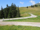 |
Le Creux 29-07-2018 14:22 7.0000°E, 46.5194°N, 1490m |
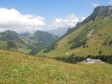 |
From Le Creux towards the Haute Gruyère valley, with the Vanil Blanc mountain on the right 29-07-2018 14:23 7.0000°E, 46.5194°N, 1490m |
 |
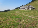
Chalet above Les Paccots 29-07-2018 14:45 6.9844°E, 46.5167°N, 1260m |