
 MTB Tour Sargans - Pizol Hut - Wildsee - Weisstannen - Sargans (23 September 2010)
 |
Sargans and the Rhine valley 23-09-2010 10:46 9.4236°E, 47.0086°N, 1370m |
 |
Gamidaurspitz and the Churfirsten as seen from Mugger Chamm 23-09-2010 12:16 9.4178°E, 46.9842°N, 2110m |
 |
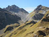
View from the Pizol hut to the south-east, left on the horizon Piz Linard, right Aguoglia d'Es-Cha 23-09-2010 12:47 9.4169°E, 46.9786°N, 2220m |
 |
Wildseeluggen as seen from the Pizol hut 23-09-2010 12:47 9.4169°E, 46.9786°N, 2220m |
 |
View from Twärchamm over the Rhine valley 23-09-2010 12:58 9.4078°E, 46.9772°N, 2300m |
 |
Wildseehörner as seen from Twärchamm 23-09-2010 12:58 9.4078°E, 46.9772°N, 2300m |
 |
Mugger Chamm and the Rätikon mountain chain as seen from Wildseeluggen 23-09-2010 13:30 9.3986°E, 46.9717°N, 2490m |
 |
Wildsee as seen from Wildseeluggen, with Lavtinasattel on the other side 23-09-2010 13:41 9.3978°E, 46.9714°N, 2493m |
 |
The Wildsee lake, the Pizol mountain and its small glacier 23-09-2010 13:41 9.3978°E, 46.9714°N, 2493m |
 |
Wildsee and Wildseeluggen as seen from Lavtinasattel 23-09-2010 14:26 9.3872°E, 46.9692°N, 2587m |
 |
The upper Lavtina valley as seen from Lavtinasattel, with left in the background Piz Dolf, Segnas and Sardona 23-09-2010 14:29 9.3872°E, 46.9692°N, 2587m |
 |
Lavtinasattel, as seen from from the Lavtina valley 23-09-2010 15:19 9.3708°E, 46.9650°N, 2010m |
 |
Canyon of the Lavtina stream above Batöni 23-09-2010 15:46 9.3589°E, 46.9597°N, 1750m |
 |
Canyon of the Lavtinabach stream 23-09-2010 15:54 9.3583°E, 46.9597°N, 1730m |
 |
Waterfall of the Muttenbach at Batöni 23-09-2010 16:11 9.3533°E, 46.9586°N, 1530m |
 |
Weisstannen 23-09-2010 16:51 9.3450°E, 46.9906°N, 1000m |