
 MTB tour Grüsch - Cani - Golrosa - Fasein - Grüsch (15 September 2007)
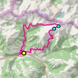 |
40 km |
| 1807 m ^ | |
 |
Valar sawmill (1897) 15-09-2007 12:05 9.6831°E, 47.0364°N, 1745m |
 |
Golrosa as seen from Hintersäss (Vals, Prättigau) 15-09-2007 12:43 9.7258°E, 47.0356°N, 1895m |
 |
Vals (Prättigau) as seen from Golrosa 15-09-2007 13:16 9.7428°E, 47.0322°N, 2110m |
 |
Golrosa, east side, with Kirchlispitzen and Drusenfluh (in the clouds) 15-09-2007 13:19 9.7439°E, 47.0317°N, 2128m |
 |
Golrosa, right in the back Fadurer Fürggli 15-09-2007 13:20 9.7439°E, 47.0317°N, 2128m |
 |
Fadurer Fürggli, view towards south-east 15-09-2007 13:54 9.7314°E, 47.0275°N, 2188m |
 |
Fadurer Fürggli, view to the south over the Prättigau 15-09-2007 13:56 9.7314°E, 47.0275°N, 2188m |
 |
Obersäss and the mountain chain of Girenspitz 15-09-2007 14:42 9.7169°E, 47.0200°N, 1985m |
 |
Salgina and, on the ridge, Maiensäss 15-09-2007 15:38 9.7208°E, 47.0069°N, 1400m |
 |
The Prättigau from Fanas 15-09-2007 16:00 9.6928°E, 46.9858°N, 1240m |